
By S.B. Meyer
Burtt and Mary Meyer were estate manager and housekeeper at Yealand Manor when it was an evacuation school during the Second World War, and after that ran the Manor as a guest house for about ten years. The article that follows is thought to have been written sometime during those years, but has only just come to light. There are a few minor points, mentioned in notes at the end, on which one would like to have been able to consult the author, but it seemed a pity not to give the Society the benefit of this careful piece of work, so it was judged best just to print it in its entirety.
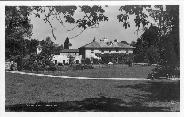
Yealand Manor occupies, without doubt, one of the finest sites in the three villages bearing the name of Yealand – Conyers, Redmayne and Storrs. These cling to the eastward side of a limestone ridge which terminates to the south in Warton Crag. The most reliable derivation of the name Yealand is from the Anglo-Saxon geahland, meaning “steep land”. In Domesday Book, and much later, it is called Jalant. The lordship of Conyers was never a large one, and was early linked with that of nearby Leighton by marriage. In later years it passed, by sale, into various hands.
The original manor house, of which all trace is lost, is known to have stood in the park at a little distance from the lodge. The site is marked by a yard pump in the shade of a group of beech trees, and it seems probable that the ancient track, called Crag-gate, which can be traced leading down from Summerhouse Hill to the village below, past the former manor house. This may well have been little more important in size than some of the larger farm houses to be seen in the district today.
The present system of roads in the village is very different to that of former days. Up to the early nineteenth century there was little wheeled traffic and the so called Coach Road from Warton which enters the village down Peter Hill dates from that time only. Other roadways were widened during that century and their sides secured by retaining walls, as may be seen along the Manor boundary.
John Ford, a ship-owner and builder of Lancaster, whose family came there in the eighteenth century from fforde Green in Staffordshire, bought the manor land at Yealand about 1800 and on it built the new mansion soon after. A great part of the stone was quarried locally, but the pillars and the steps of the portico, and possibly the casing of the main walls, came from further afield.
Two engraved stones – one above a side door and the other over a gateway in the garden – were brought from the family home in Lancaster, the site of which is now occupied by the Judge’s Lodging1. The Latin motto on one stone suggests that wealth may prove an incumbrance. The large bell, inscribed “Lady Cathcart” is reputed to have come from a sailing vessel of that name belonging to the family.
The striking clock in the turret is probably of composite origin, as one of the three faces does not match the other two in size. Beneath the clock is a deep well, hewn from the solid rock. Formerly this supplied all drinking water to the house; for other purposes water was piped from catchments on the hillside. Later, the large covered reservoir, to the north side of the house, was constructed. In the distant past, smaller wells were sunk at many points on the estate, emphasising the extreme difficulty of maintaining a water supply on this rock foundation.
The manor walls themselves rise on solid rock, and in the surrounding pastures the soil is rarely of any depth. To gain such depth is doubtless the reason why the kitchen garden was made at such a distance from the house. This garden is contemporary with the house, but the rock garden was developed by the late Rawlinson Ford and his wife, who were the last to occupy the Manor as a private house. It subsequently became a guest house and, during the last war, a school.
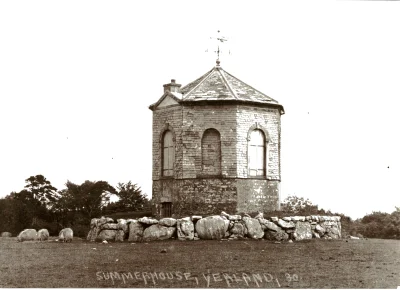
It is known that the Summerhouse was at one time used as a club house by the Yealand Cricket Club, and that during the war the scouts were allowed to use it. Its history would repay further research.
Rising sharply above the manor is Summerhouse (formerly Barrow) Hill, on the summit of which John Ford built his gazebo2, with a clearance in the trees towards Ingleborough and a view, then
unobstructed, of the port of Lune3 to the south. With a telescope the family could identify ships at the quayside. An interesting feature hereabouts is a number of massive boulders of Shap granite
which were left in the path of the ice-age glacier.
Alongside the primitive Crag-gate (referred to above) is an early grave site, marked by an old thorn bush, which was excavated by John Ford in the second decade of the last century and from which he took a clay urn containing bones and ashes. Tradition has it that this urn was later purposely destroyed by a superstitious house-maid. Many other signs of burial and tribal gathering from earliest times are in evidence; notably a few remaining stones of what is held to have been a circle4. The name Cringlebarrow, which is applied to the northern end of the ridge, is derived from Old English kringla, a circle.
Several ancient rights-of-way cross the Manor lands; one coming along Little Deepdale at the back of the Rock Garden and known as the “corpse road” was the quickest route from Far Yealand to the then parish church at Warton. Beyond this track is the real Deepdale, an impressive basin caused by rock faulting, and nearby are to be seen many specimens of the native yew tree. Those yews were accompanied formerly by a thin growth of alder, ash, birch and thorn. Later, coppice woods were developed to feed the charcoal industry and to provide material for bobbin making and other crafts. A century and a half ago the magnificent beech and other standard trees, including some fine conifers, were planted around the Manor and there are now more than forty varieties of tree on the estate.
Notes
- The Judge’s Lodgings date back to the seventeenth century. Perhaps the text should have read “near” the site of the Judge’s Lodgings. ↩︎
- Gazebo. The “Summer House” is older than this. Mr Tom Clare (personal letter) dates it to c.1750. ↩︎
- Port of Lune. Presumably Sunderland Point, or Glasson Dock, rather than Lancaster. ↩︎
- The idea of a stone circle on Summerhouse Hill has not been supported by later work. ↩︎
Published in Mourholme Magazines Issue 19 1992