
By A.C.H. Olivier (Assistant Director of the Cumbria and Lancashire Archaeological Unit)
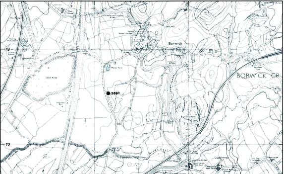
Excavation of a circular dished earthwork c35m in diameter was undertaken by the Cumbria and Lancashire Archaeology Unit in advance of gravel extraction. Work was conducted on behalf of the Department of the Environment with the permission and support of Tilcon, Ltd, between 8 August 1982 and 22 October 1982. This hitherto unclassified earthwork lay on the crest of a small fluvio-glacial hillock 13.5m above ordnance datum (SD 523725), directly overlooking the valley of the river Keer as it runs into Morecambe Bay. The entire area is underlain by carboniferous limestone.
Total excavation of the feature revealed a substantial sub-circular enclosure of large limestone boulders (0.4 to 0.7m high), completely covered by a cairn of smaller stones and pebbles. The site of the enclosure had apparently been deliberately prepared and cleared prior to the construction of the monument. No trace of an old ground surface was recorded below the enclosure, and the buried coil was identified as a truncated stagno-podzol1, which was therefore considered unsuitable for thin sectioning. The pH of this horizon was 7.352, and therefore too high for non-differential pollen preservation. Although some of the boulders were clearly derived from the immediate fluvio-glacial deposits surrounding the site, the great majority displayed erosion patterns consistent with long exposed pavement limestone, and were probably transported to the site at Manor Farm from nearby limestone outcrops either at Warton Crag or Hutton Roof 2-3 miles distant.
The eastern and southern perimeter of the enclosure was extremely well defined by a carefully placed free standing kerb composed of a single outer course of slightly smaller boulders. The main body of the enclosure was most substantial to the north where it survived in places to a width of around c.9m and was several courses of boulders thick. Although varying considerably in width and thickness, no easily identifiable pattern could be observed in the structure of the enclosure. It was therefore difficult to distinguish whether the location of some internal boulders was the result of deliberate positioning or merely tumble derived from either natural erosion or perhaps deliberate slighting.
Close to the centre of the enclosure lying in situ on the cleared ground surface, immediately beneath the smaller stones of the overlying cairn, was the surviving portion of a contracted inhumation burial, lying on its left side. Associated with this burial were two very well preserved bronze grave goods – a simple Early Bronze Age Flat Axe, and a flat rivetted dagger blade of the same date. The blade of the dagger is triangular (although the tip is missing), with three stout plug rivets, probably belonging to Gerloff’s type (Masterton, 1975, p.58), no trace of the handle survived. A second inhumation was recorded with a ‘cell’ of limestone boulders along the inside edge of the southern portion of the enclosure. This burial was in an extended crouch, lying on its right side, laid on the flat cleared surface immediately below the stones of the cairn. The bones only survived partially, in a very fragmentary condition; however the skeleton was clearly associated with a second, less well preserved Early Bronze Age flat dagger blade, of similar form to the example described above. The presence of this inhumation in an apparent cell highlights the possibility that other negative areas of boulders within the body of the enclosure may also have been ‘burial cells’, although no traces of such use survived.
The overlying cairn of stones was clearly of one single build, and although large quantities of fragmentary human skeletal remains were recovered during its removal, it was not possible to make any real stratigraphic distinction amongst this material. The positions of all skeletal remains were recorded and plotted three dimensionally, and the scatters of inhumed bone formed a number of fairly discrete concentrations (c.11), generally limited to areas of c.l-1.5m diameter. Most of these concentrations were completely unrelated to the location of cells within the underlying boulder enclosure, and it is possible that they were derived from earlier burials disturbed by and presumably mixed with the construction of the cairn. Such burials may have consisted of bodies either laid and exposed on the cleared ground surface inside the enclosure, or under individual cairns which were then disturbed by and completely mixed with the later covering cairn, No physical trace of any such smaller cairns was observed during the excavation of the overlying calm. A phosphate survey of the cleared ground surface was conducted at 50cm intervals and it is hoped that analysis of these results may indicate the original presence of such inhumations as well as the possible existence of additional inhumations (now completely decayed) within some of the ‘cells’ of the enclosure3.
The problems of interpreting such analysis are of course recognised; positive results may do no more than reflect the locations of the bone concentrations already identified, and indeed may merely derive from these concentrations by the downward leaching of phosphates through the cairn. Seven discrete concentrations of cremated bone were also recorded mixed with the main body of cairn material. These scatters ware slightly more extensive (c.l.5-2m) than those of inhumed bone, with which they wore generally mutually exclusive. The cremated material was also mixed with quantities of extremely small and fragmentary Bronze Age Pottery (mainly recovered as a result of dry sieving). This pottery was in very poor condition, few sections across the wall of any pot survive and most pieces are merely core fragments. Those fragments of external face that do survive are so small that it is difficult to judge whether the pots were originally plain or decorated. Although in poor condition the pottery associated with each cremation is of fairly high quality and presumably represents some form of funerary urn; it is unfortunate that no more detailed classification is possible. The cremations describe a general arc in the south and east portion of the cairn which appears to be eccentric to the underlying enclosure. A possibility therefore exists that although the cremations occurred in the same stratigraphic position as the probable inhumations described above, they may actually represent insertions into the surface of the existing cairn, perhaps sometime during the Middle or Late Bronze Age. However, if this was the case, it was certainly not possible to observe such insertions in the cleaned surface of the cairn.

The overall simplicity of the site stratigraphy therefore belies what may be a rather complex sequence of events, for which there is little positive evidence. The construction of a substantial limestone enclosure very early in the Bronze Age is attested not only by the metalwork associated with the two in situ inhumations, but also by the presence of two Late Neolithic flint arrowheads recovered from the cleared ground surface below the enclosure. It is difficult to ascertain the use actually made of this enclosure, although it may have contained inhumations, either exposed, laid in cells, or under individual cairns. The fairly clean nature of the truncated subsoil illustrates that this enclosure was not in use for any great length of time before being totally covered by a large cairn of smaller stone. Immediately prior to this, however, it is likely that the main inhumation was laid in the centre of the enclosure and indeed may have provided the impetus for the construction of the cairn, which would have disturbed any pre-existing burials. It is thought likely that at a later date the monument was possibly reused with the insertion of the cremations.
Although clearly related in a general way to the ring-cairn form, a number of factors do appear to differentiate the site at Manor Farm from the many ring-cairn variations identified by Lynch (1979, a & b).The absence of an internal kerb and clearly defined central space together with the fact that the entire monument, including the external kerb, was covered by an overlying cairn, probably part of the original design, particularly serves to illustrate these differences. In addition, the size of the monument (c.35m diameter), the probable number of recorded inhumations (c13), and the quality of the associated metalwork further emphasise the importance of this major northwestern Early Bronze Age funerary monument.
Notes
- Identification by C. Bendelow (Soil Survey of England & Wales, Penrith Office), and J. Keeley (Ancient Monuments Laboratory) ↩︎
- Determination by P. Howard, Experimental Officer, Department of Archaeology, Lancaster University ↩︎
- Analysis to be conducted by D. Gurney (Fenland Archaeological Associates) ↩︎
Bibliography and Further Research Data
- Gerloff, S., 1975- ‘The Early Bronze Age Daggers in Great Britain and a reconsideration of the Wessex Culture’, Prahistorische Bronzefundre. Abteilung VI. Band 2. Munich.
- Lynch, F., 1979a. ’Ring-Cairns and related monuments in Wales’, Scottish Archaeological Forum, Vol 4 (1979), pp. 61-80.
- 1979b. ‘Ring Cairns in Britain and Ireland: their design and purpose’, Ulster Journal of Archaeology, Vol 42 (1979), pp. 1-19.
- Full report available
- Supplementary Information
Published in Mourholme Magazines Issue 7 Spring 1984