Sub-Menu
Early History
Yealand Redmayne shares a wooded limestone ridge with Yealand Conyers, its neighbour to the south. Redmayne and Conyers were the family names of medieval overlords who ran the two estates. The name Yealand probably comes from the Anglo Saxon word geah-land meaning steep- or high-land.
While Yealand Conyers is dominated by gentlemen’s residences, Yealand Redmayne is characterised by a string of traditional, stone-built farmhouses and cottages which line Silverdale Road, facing narrow strips of farmland. Storrs Farm dates from 1666 while Brow Foot Farm, in Yealand Storrs has a datestone from 1627.
Another of the older farms, Hill Top in the centre of the village, has an unusual spiral staircase and the remains of a communal oven. Some local traditions suggest this was the home of Redmaynes most famous son, the Quaker activist and writer Richard Hubberthorne (d. 1662). An officer in Cromwells New Model Army, Hubberthorne was a close friend to George Fox, the founder of the Quakers. The two men debated religious doctrine with King Charles II in 1660 . But Hubberthorne was later arrested for his views and he died in Newgate prison in 1662.

A Stone Age arrowhead discovered by farmer Jack Seed when ploughing near the Moss. The earliest evidence of human occupation in the parish was retrieved from Storrs Moss, in neighbouring Yealand Storrs, during the 1960s. Archaeologists from Liverpool University unearthed a structure of socketed wooden planks probably a causeway preserved in the peat at the edge of the Moss. They also found pieces of flint and fragments of a wooden bowl. The oldest remains were dated to around 4,200 BC, the end of the Mesolithic period. Local farmers Jack Seed and his daughter Alice,from Browfoot Farm frequently discovered Stone Age tools while ploughing fields alongside the Moss. Most are now kept by Kendal Museum.
In the woods above Yealand, the picturesque Deepdale Pond was a popular site for picnics up until the First World War. But shock waves from an explosion at the White Lund munitions factory in Lancaster in 1917 are believed to have opened new fissures in the limestone, causing the water to drain away. The pond is now a bog.
A plaque on the wall of Yealand School explains that it was founded in 1841. During World War II the village name on the plaque was painted over to thwart German paratroopers who might have needed to check their location.
Yealand Hall , in the neighbouring hamlet of Yealand Storrs, is said to date back to Tudor times. Until recently it was home to Sir Ernest Sanderson Sandy Temple, a former circuit judge and landowner who was often to be seen driving around the village in a carriage pulled by a zonkey a zebra-donkey cross.
Lumps and bumps in the field above Brow Foot Farm have prompted speculation that it is the location of a deserted village, possibly abandoned during the Black Death in the fourteenth century. The site has not yet been excavated.

The hoard of Viking coins and jewellery unearthed in 2011 The third biggest haul of Viking coins and jewellery ever discovered in England was unearthed by a metal-detectorist in the parish of Yealand in 2011. The find was quickly dubbed the Silverdale Hoard to put treasure hunters off the scent.

Leighton Hall View of Leighton Hall from Summerhouse Hill
People have been admiring the view from Summerhouse Hill for at least 3,000 years. A Bronze Age kerbed cairn on the south eastern edge was excavated in the 1780s . Archaeologists are still debating whether the limestone blocks on the hills summit are the remains of a massive stone circle. A grass-covered limestone plinth is all that survives from the Georgian Summerhouse which gave the hill its modern name. The hill-top was until recently the village cricket pitch.
Leighton Hall has been home to the major landowners in the parish since the thirteenth century. Its current gothick faade was constructed in the 1820s when the celebrated Lancaster furniture makers, the Gillows, took over the estate. Their descendants are still in residence.
Yealand Conyers is almost over-endowed with grand houses. Yealand Manor originally called Morecambe Lodge was built c1800. During the Second World War the Quakers used it as a school for evacuees. The celebrated children’s writer, Elfrida Vipont, author of The Elephant and the Bad Baby, was headmistress, and lived in the village for many years.
Another Georgian mansion, Beechfield, was once home to Lancasters Conservative MP, Sir Fitzroy Maclean. A friend to Sir Winston Churchill and a founder member of the SAS, he is said to have been the model for Ian Fleming’s James Bond.
The village boasts two churches: St Marys Catholic Church, built by Squire Richard Thomas Gillow in the 1850s, and the C of E’s St Johns, which also dates from the nineteenth century. The oldest place of worship – leaving aside the possible stone circle belongs to the Quakers. The Yealands figured prominently in the formation of the movement. Their founder George Fox preached here in the 1650s when local toughs thought to be from Borwick Hall threatened to break up a meeting. Early gatherings were held in Quaker cottages in the village, before the present Meeting House was built in 1692. The Old School next door was started by local Quakers in 1709 and closed in 1920. A clock and plaque on its outside wall commemorates the Quaker Martyr Richard Hubberthorne, from neighbouring Yealand Redmayne, who was imprisoned for his beliefs and died in Newgate jail in 1662.
Until about 1860 the building at the top of the village now called the Coach House and its adjacent cottages formed part of a busy flax weaving shed. For many years the village was a mix of gentlemans residences, farms and cottages. Today only one working farm survives.
The New Inn dates from the 1680s. Fine plasterwork above the fireplace in the bar is a reminder of the Jacobite rebellions of the eighteenth century. Rediscovered by former landlady Mrs Bernie Taylor during restoration work, the plaster is dated 1727 and is decorated with stags heads and acorns: the symbols of the Stuart dynasty.
Old Hall, the elegant seventeenth century farmhouse opposite, was previously home to the late Colonel Robin Hartley, whose family owned the pub. He visited the New Inn every day to test first-hand the quality of the Hartleys XB bitter.
Publications and articles that relate to Yealand:
Early History
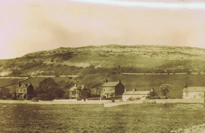
Warton has long provided homes to people. On the rocky outcrop of Warton Crag, standing 163 metres (535ft) high to the North of the present village of Warton, caves provided shelter from Palaeolithic times, more than 10,000 years ago and on the summit of the Crag people in the Iron Age built a hill fort, with ramparts and ditches, huts and tumuli. Objects made of horn, bone, bronze, iron and pottery have been found there. Other archaeological finds include a stone axe from Langdale in the Lake District as used by Neolithic farmers to clear land , the Keer Valley may have been used as a route to the sea for their export also an iron sword with a bronze hilt and sheath, probably made in Romano-British times.
Middle Ages

Warton Parish Church Warton Parish Church was in existence by 1208, but its dedication to St Oswald, a 7th century Christian King and Martyr and the circular shape of the churchyard, as seen on the tithe map of 1846, indicates Anglo-Saxon origins. St Oswald is also commemorated in Senset Well, off Borwick Lane. The oldest part of the present building is 14th century.
The Domesday Book shows that Warton was part of the King’s land in Yorkshire, it was one of 12 manors held by Thorfinnr, Lord of Austwick, they were worth 43 carucates to the geld. It became part of the Barony of Kendal, with castles in Kendal and Mourholme. The site of Mourholme castle was at Dock Acres, under what is now Pine Lake, the flooded gravel pit. In 1200 King John granted a charter to Gilbert FitzReinfred for a Wednesday market.

Warton Old Rectory Later in the 13th century, the Lord of the Manor granted a borough charter to Warton, 44 burgage plots, each measuring one rood, acre, were laid out on either side of Main Street, from Crag Road to Coach Road and Senset Well Lane, the burgesses being freed from services to the Lord of the Manor. Their pattern can still be seen, with the access lanes between the houses going to Back Lane, the site of the common arable fields, where they each had one acre of land. Wartons Manor Court was held in the Rectory, the great hall with service rooms and an upper floor, built in the late 13th or early 14th century by the rector, Marmaduke de Thwengs sons. However Warton failed to prosper as a borough, it reached its peak in the 14th century and by the 16th century had ceased to be recognised as a town.
School

Archbishop Hutton However the needs of local children and elderly people were not neglected and in 1594 a Free Grammar School, Deo et bonis literis (For God and good education) and the Hospital of Jesus, almshouses for six poor men, were founded by Matthew Hutton, the Charter being granted by Queen Elizabeth I. Matthew Hutton, born in 1529 in Priest Hutton, studied at Cambridge, where he distinguished himself by his ability in the theological disputations before Queen Elizabeth and established himself as an able scholar and preacher. He became Bishop of Duham in 1594 and Archbishop of York in 1595. Part of the old school at Cross Bank is now a Brewery, while primary school children have enjoyed the facilities of a modern Archbishop Hutton School in Back Lane since 1991.
George Washington’s Ancestry
There is a tradition of flying the Stars and Stripes flag of the USA on the 4th July every year to commemorate the first president of America, whose ancestors came from Warton and whose seal of two bars and three mullets, which can be seen on a stone in the church, may have inspired the design of the American flag.

Washington Coat of Arms Industrial Revolution
People in Warton had been involved with farming, weaving, fishing, quarrying and limestone burning, with some mining on Warton Crag and some ship building. But the coming of the Lancaster Kendal canal, turnpike roads and railways, from the 1790s onwards, which bypassed Warton, led to a change in the balance of population and in employment opportunities. Carnforth overtook Warton as the township with the largest population in the decade between 1861 and 1871. Carnforth Ironworks opened in 1865 and Wartons population was swelled by iron workers living in houses built for them by the Company in Dudley, the part of Millhead on the Warton side of the river Keer, Bessemer Terrace, Albert Street and William Street.
Wartons resources of stone and gravel were used when Englands first motorway was built, the Preston bye-pass in 1958 and the Lancaster bye-pass in 1960. The quarries are now part of the Warton Crag Nature Reserve and the gravel pits are flooded and feature in the Pine Lake and other leisure village complexes. Limestone also features as the gnomon of the Sparrow Park sundial, on the corner of Sand Lane and Mill Lane, a Warton Village Society project to commemorate the millennium.

Silverdale – Lindeth Boundary Stone Lindeth
The hamlet of Lindeth lies to the north west of the main part of Warton, and to the South of the township of Silverdale, Heald Brow, at 245ft (75 metres), is its highest point. Quicksand Pool, a stream which flows into Morecambe Bay from Leighton Moss, divides the moss land between Warton and Lindeth.
Finds including a Bronze Age sword and Roman remains show evidence of early occupation of the area. A 13th century Baron of Kendal, Walter de Lindsay, took his name from the hamlet. Farming, fishing and salt making were probably the main occupations. There is also some evidence for ship building in the 17th century and it is likely that cattle drovers, using the cross bay route, came ashore at Cows Mouth, the rocky inlet below Jack Scout.
Lindeth Tower at Gibraltar Farm

Lindeth Tower The fashion for sea bathing in the early 19th century reached Lindeth and the Britannia Hotel, now the Silverdale Hotel, provided bathing machines and one of Shore Cottages was the Bath House. Elizabeth Gaskell, the novelist spent holidays in the area and did some of her writing in Lindeth Tower, the summer house built in 1842 by Henry Paul Fleetwood, a banker from Preston, who also built Lindeth Lodge, now known as Wolf House.
Jenny Brown’s Point lies at the seaward edge of the saltmarsh separating Warton Crag from Jack Scout, and contains much of historical interest. The origin of its name is uncertain, though an interesting 1984 Mourholme Magazine article (see here pages 9 and 10 – separated on this pdf file due to the copying process!) argues that it is named after a past inhabitant of the cottages located there. A tall chimney can be seen – and this is the remaining feature of a copper-smelting operation that took place between c1790 and 1800, using ores extracted from the hills above and from Warton Crag. Its short operational life evidences the paucity of minerals found locally. Close by, to the north, low tide shows the remains of a long stone embankment stretching a mile into the sea, the remains of a controversial land reclamation scheme. An Act of Parliament (1874) permitted the Warton Land Company to enclose an area stretching from Jenny Brown’s Point to Hest Bank. Work began in 1875, building the embankment from limestone extracted from the quarry at Jenny Brown’s Point, but proved much more difficult than had been expected by the surveyors and engineers. In 1885 the company was declared bankrupt.

Matchless Sketch Just beyond the remains of the embankment is the site of a boating disaster – the sinking of the Matchless in 1894. A pleasure boat sailed from Morecambe with 33 passengers, taking the much-travelled route to Grange, and carrying a cargo of millworkers holidaying in Morecambe. A sudden squall caught the boat broadside, rolled the boat over, and resulted in 25 passengers drowning. 8 others, together with the boat’s skipper, were saved by other pleasure boats. The inquest that followed was brief and hurried, and seemed to be something of a whitewash. The full story of Morecambe Bay’s biggest ever loss of life has been researched and is published by the Society (see here).
Because of its separation from the main part of Warton, Lindeth seemed more closely allhttps://staging.mourholme.org.uk/Publications/Booksied with Silverdale and officially became part of the ecclesiastical parish of Silverdale in 1871 and part of the civil parish in 1935.
In 1801 the population of the township was 464 and fluctuated between 400 and 600 until the number exceeded 1000 in 1871 when there were 1035 people. By 1931 the population of Warton-with-Lindeth was 1694.
Early History
How are we to account for the name Carnforth? According to one source it is derived from the Celtic words Cairn, a memorial heap of stones, and Forth, a haven or harbour. Another source has its derivation from Kerne (old name for the River Keer) and Forde (a river crossing). It seems that the local branch of freemasons favours the latter, as the old National School, where its meetings are held, now bears the name Kerneford Hall. There is little else to relate of the early history, except that the future King Charles II is said to have encamped his army in the vicinity in 1651, and in a gravel pit near the railway station a number of human bones, skulls and even whole skeletons were at one time found just below the surface.
Growth
Until well into the nineteenth century Carnforth was an insignificant element in the parish of Warton, with most of the dwellings lining what was then the main road (now North Road). One or two of these buildings dating from the seventeenth century still exist. Things changed with the building of a new main road (the A6) and, more importantly, the coming of the railways. In 1846 the Lancaster & Carlisle Railway built a wayside station which gained much more importance in 1857 when it became a junction with the arrival of the Ulverstone & Lancaster Railway, and even more so in 1867 when the Furness & Midland Railway provided a link to Wennington and so on to Leeds. By the early 1860s Carnforth was seen as an ideal location for an iron works, and in 1866, largely thanks to Mr. H.J. Walduck of Manchester, the Carnforth Haematite Iron Company gave added impetus to Carnforth’s growing importance. A steel works was set up later, but it was less successful, lasting for only a few years before closure in 1889.
In 1873 Christ Church was built, so that Church of England parishioners did not have to travel to Warton, and other denominations were well catered for, though a cemetery was not provided until 1925. By this time Carnforth had far outstripped its parent Warton in importance, though many of the iron workers lived in Millhead, just the other side of the River Keer and were therefore technically in Warton. Edward Barton, the manager of the Iron Works, was a driving spirit, much to the fore in concerns such as Carnforth Gas Company (1872) and Carnforth Water Company (1877) and when Carnforth achieved Urban District status in 1893, he was its first chairman. In one respect Carnforth was backward, not having street lighting installed until 1885. Carnforth had a strong temperance movement, but it was nevertheless not short of hostelries. In Market Street, the main shopping development of the 1880s, was the The Queens Hotel built in the 1860s, and The Station Hotel, built in 1880, while at the junction with Lancaster Road was the Carnforth Inn, allegedly built in 1620 (it was reconstructed in 1904). On North Road was the Shovel Inn near the site of the demolished Golden Ball, and further along Kellet Road was the Cross Keys. In 1887 an enlarged Post Office was opened next to the railway station, and Conservative and Liberal Clubs flourished . At the same time Carnforth Co-operative Society, breaking free from the Lancaster & Skerton Co-op, had its own premises built in New Street; the Co-op Hall was to become a favourite venue for entertainments and meetings.
The Twentieth Century and Partial Decline.
As it entered the twentieth century Carnforth was considered to be an up and coming township, and the population had risen from a mere 300 in 1850 to 3000 in 1900. The Iron Works had had its hard times, but was still a thriving concern, though its lean periods led to rapid turnover of population. The railways were still a major influence, and sand and gravel quarries continued to be important as they always had been. The expansion of the 1870s and 1880s had slowed down, but a small council house estate was built, a purpose-built cinema was opened in 1920, and a playground was built near to the canal. The 1920s and 1930s were difficult times, so much so that the ironworks ceased production in 1929, but the railway was still a major employer. After the 1939-45 war the council estate was greatly enlarged and as the century progressed more housing estates were built. The late 1950s early 1970s saw considerable changes, with the Church School moving to a new site, the opening of Carnforth Secondary School (now Carnforth High School with academy status), the closure of the once very popular Roxy cinema and, more important, the closure of the railway engine shed and Carnforth’s main line platforms, so that much of Carnforth’s importance as a railway centre vanished.
The Current Status.
Not all is doom and gloom. The derelict station buildings have been rejuvenated as Carnforth Heritage Centre, with regular exhibitions and its Brief Encounter connection which attract coach loads of visitors; the canal basin is a marina; Carnforth Bookshop is one of the largest in the country; and the Co-op, though no longer of Carnforth nor in its original premises, ensures that the more modern supermarkets do not have things all their own way.

Carnforth, 1968 
Carnforth Station, 1890s Early History

Priest Hutton Map 
Ploughing The first recorded mention of Priest Hutton was in 1086 in the Domesday Book where it was called Hotun. The township, also previously known as Presthotone and Nether Hutton, lies to the east of Warton. In 1086, like Warton, it was one of the manors held by Torfin of Austwick. At the end of the 16th century the manor of Priest Hutton was acquired by Robert Binloss of Borwick, although by then parcels of land had been endowed to Warton Church.
It seems strange to think that the minute Whitebeck stream that trickles through the Parish once had its own mill and was the cause of a dispute in 1560 between the Ashton and Middleton families. Upp Hall, now a farm, is an early 18th century house and there are remains of a possible mansion earby. A medieval moated enclosure and fishponds survive as earthworks to the east of the house. The village contains several 17th century dwellings and is surrounded by enclosed fields within which the medieval ridge and furrow system can still be seen.

Matthew Hutton by Francis Perry, etching, possibly mid 18th century However, Matthew Hutton, born in Priest Hutton in 1529, is the most notable person to come from the township. He went on to be educated at Cambridge. Matthew Hutton adopted the Protestant faith and after Elizabeth was crowned he became one of the leading clerics in England. He became Master of Pembroke College and after holding a number of positions he became Bishop of Durham in 1589 and Archbishop of York in 1596. In 1595 Matthew Hutton founded Warton Grammar School and almshouses. A descendant of his, another Matthew Hutton (1693-1758), also became Archbishop of York and subsequently Canterbury. To this day the Primary School in Warton is known as Archbishop Hutton Endowed School. Priest Hutton school was built in 1897 and closed in 1978. The school logbook records much illness among the children in the early years of the 20th century and also time taken off for farm work. The original school opened in what was the village tithe barn where church services were also held.

St Mary The Anglican Church of St Mary, is just within Borwicks boundary, but the Memorial Hall is just in Priest Hutton. The church, built in the gothic revival style, was built for William Sharp of Linden Hall in 1894-1896 in memory of his wife, Clara Sharp, who had died in 1889. The architects were Paley, Austin and Paley of Lancaster. The original Memorial Hall, pulled down in 1988 to make way for a new one on the same site, was erected in memory of the men who gave their lives in the First World War.

Tewitfield Methodist Chapel The canal, which was originally intended to link West Houghton and Kendal, was opened in 1797. The canal brought much work to the area and about the same time Methodism grew in popularity. Tewitfield Methodist Chapel was within easy walking distance of the village via Kirkgate, an ancient stoned road. The chapel is thought to have been originally an alehouse used by the canal navvies! In 1970 the M6 motorway cut through the canal isolating the magnificent flight of locks at Tewitfield, which sadly are now no longer in use. Tewit is a dialect name for the lapwing.
The A6070 road to Burton in Kendal was a drovers road that was repaired and widened by an Act of Parliament in 1751. Later in the 19th century it became part of the Garstang to Heron Syke Turnpike.
Priest Hutton is the smallest of the Warton townships, both by population and households. In 1851 there were 213 residents and in 2001 there were 177. Priest Hutton is so small that it does not have a parish council. Instead it has regular parish meetings. At the end of WW2 the vast majority of the houses were relatively modest properties that were rented to farm labourers, quarry and canal workers. The village did have, however, a school, shop, post office, smithy, joiners workshop, basket makers and a slaughterhouse. Now all of these have disappeared, being converted into residences. In the last 150 years only twelve or so houses have been built. Mains water was brought to the village in 1936. Prior to that, the inhabitants relied upon, wells, hand pumps and rainwater. Electricity also came to the village in the early 20th century. However the village still has no mains sewage, gas, street lighting, pavements or signs for the roads. In some ways the village has changed little in the last 150 years, but the majority of the population no longer work on the land, but commute to Kendal, Lancaster, Preston, Manchester and the surrounding area.
Early History

Borwick Hall 
Borwick Chapel Foundation Borwick Hall’s impressive tower has dominated the picturesque village green for more than six centuries. But village history goes back long before the Hall. An important Bronze Age funerary monument was excavated near Manor Farm in the 1980s. Dating from between 1740 and 1640 BC, its cairn yielded pottery fragments and human bones, as well as two metal daggers and an axe. Archaeologists also identified a fascinating array of bird bones buried within the cairn everything from woodcock to wrens. At nearby Docker a hoard of bronze Roman coins was found in 1975 by a local man washing mud from his boots in the River Keer, while at Tewitfield a modest silver Viking hoard was unearthed in the 1990s.
Borwick Hall
It is possible that Borwick Hall’s fortifications were initially built from wood. But in the late fourteenth century a stonepele tower was erected to protect people and cattle from marauding Scots. The Hall was extended in the sixteenth century by the Bindloss family, a wealthy dynasty of Kendal clothiers, who added the impressive gatehouse and the adjacent stable-block for the pack-horses which carried Kendal cloth south to London.
Sir Robert Bindloss (also spelt Bindlosse) was elected Member of Parliament for Lancaster at the age of sixteen and his immense wealth is said to have prompted a contemporary saying: As rich as Sir Robert in the North. Officially he backed Parliament in the Civil War but he seems to have had Royalist sympathies. In 1651 he was diplomatically absent when Borwick Hall accommodated the future Charles the Second after his defeat at the Battle of Carlisle. Local tradition has it that a young local woman attended His Majesty in a first floor bedroom: a liaison that produced one of his many illegitimate children.

Borwick Hall Gatehouse The datestone on Borwick Hall’s gatehouse carries the date 1650, and the initials of Robert Bindloss and his wife, Rebecca.

Dr Richard Sherlock Conflicts
Large limestone blocks on the village green mark the foundations of a chapel where Dr Richard Sherlock — formerly a chaplain to Royalist troops — preached dangerously unfashionable Catholic sermons in the 1650s. He clashed in debate with the Yealand Quaker, Richard Hubberthorne. And George Fox, the founder of the Quaker movement, complained that armed men from Borwick Hall had tried to break up one of his meetings. In the Jacobite rebellion of 1715 Ralph Standish of Borwick Hall supported the Catholic and Stuart causes. But he was captured at the Battle of Preston where the rebellion was crushed.
Towards Modern Times
The Lancaster canal arrived at Borwick in the 1790s and the railway in 1867. But Borwick was now taking a backseat in national affairs.
The Jackson family who lived at Borwick Hall in the mid-19th century were innovative farmers, who introduced short-horn cattle and Leicester sheep to the area. Meanwhile the Sharps of Linden Hall– just across the green — commissioned fashionable Lancaster architects Austin and Paley to build St Marys church in 1896 as a chapel of ease, still subordinate to the Parish Church at Warton.
Borwick Hall fell into disuse in the later 19th century until the arrival of the former music critic of The Times, JA Fuller Maitland in 1911. After his death in 1936 it became a country club and during the second World War it was taken over as a military base before being purchased by the County Council who now run it as an outdoor activity centre.
Timeless
Today with its cottages and farms clustering around the green in the shadow of the Hall, the village retains a charming, timeless quality. And it is true that Borwick has not expanded as fast as some villages. When the first national census was carried out in 1801 its population was 208. By 2001 it had risen to 210.

Borwick Village Green Early History
Prior to the arrival of the railway the Ulverston to Lancaster line in 1857 Silverdale was a small collection of semi-isolated farmsteads, lacking even a discernible village centre. Its population in early censuses (1821 to 1851) was around 240, and its economy was largely agrarian, with farms centred on the relatively few pockets of workable soil found upon the underlying limestone. But even before the advent of a local railway station Silverdale was referred to as much frequented by visitors and tourists, for whose accommodation there is a good inn (Mannex Directory of 1851). After the arrival of the railway, the population grew steadily to reach 1519 (2011 census).
The origin of its name is lost but almost certainly has nothing to do with the silver colour of its birch and hazel woods, or its limestone outcrops. Selredal is its earliest recorded name (1199), and may derive from a Norse name, Soelvers.
At the time of the Norman Conquest it is thought that Silverdale was part of an estate administered from Beetham and held by Tostig Godwinson, Earl of Northumberland, and brother of King Harold. This estate included Yealand, Silverdale, Borwick, Farleton, Preston Richard, Heversham, Hincaster and Levens. In 1092, following his successful putting down of a rebellion in Durham, Roger of Poitou, a Norman, was granted extensive lands in the north-west and elsewhere, including Beetham. Later Silverdale was part of the Barony of Kendal, and by the sixteenth century was recognised as a manor in its own right.
Churches

Silverdale Chapel, built 1829 Before the Reformation there was a chapel at Silverdale described as a chantry which probably ceased to be used regularly after the Reformation. During the Commonwealth period the ‘poor inhabitants (were) forced to hire a poor minister for 20 nobles per annum,’ but a stipend of 40 was afterwards assigned to the minister, Samuel Harrison, out of the rectory of Warton. This grant would cease at the Restoration, but in 1680 the chapel was built on the old foundations, and soon afterwards a curate seems to have been appointed. A stipend of 3 3s. 4d. was given by the vicar and others for reading prayers every Sunday afternoon, and soon afterwards the Dean and chapter of Worcester, on increasing the vicar’s stipend, required 5 to be given to maintain some kind of service at Silverdale ‘to keep out dissenters from entering upon the said chapel.’ The vicar seems to have grudged this payment to a curate, and preached there himself once a month. In 1738 Silverdale was ‘supplied by a curate; sermon and prayer there once a month.’ Later an endowment was secured, and from 1756 there seem to have been regular ministrations. The chapel was rebuilt in 1829. A separate district was assigned to it in 1871. The present church of St. John was built in 1886, the old one being used as a mortuary chapel (now a private residence).
The earliest Methodist services in the area were held at Arnside Tower Farm from the 1830s. In 1873 a Bolton cotton spinner, John Hebden, came to Hill House (now the Woodlands Hotel), and made available one of his outbuildings for Methodist services. This became too small for the congregation it had attracted, and Hebden provided a field as the site for a new chapel, which was built and consecrated in 1879.
Water and Sanitation

Woodwell, Silverdale Silverdales water was traditionally supplied from rain collected from roofs, stored in tanks and cisterns, or from the numerous wells and springs arising from the limestone geology. It wasnt until 1938 that a piped supply to the village was arranged by the Lune Valley Water Board, and the Haweswater-Manchester aqueduct was tapped for this purpose.
Silverdales geology has largely defeated the construction of a drainage system, and sewage is disposed of through septic tanks or cesspits. Lack of drainage has imposed a natural limit on the size of the village, preventing much expansion.
The Coming of the Railway
The iron industry in Furness was the main motivation for the development of the railway in our area. From the south, the railway had reached Lancaster in 1840, and by 1846 the Lancaster to Carlisle line was constructed. In 1857 the line from Lancaster to Ulverston, via Carnforth, was built. There was local controversy in Silverdale over the route to be taken: the easiest route would have been to continue to follow the coastline for the stretch from Carnforth to Arnside, but prominent Silverdale landowners were keen to protect their interests, and the alternative route was adopted albeit by-passing the village centre by over half a mile.
The railway opened up new business opportunities to transport limestone from Silverdales quarries, fish from the small local fishing industry (mainly cockles and shrimps), and to bring in tourists and private individuals with the money to invest in the larger villa-style houses dotted around the village.
Boundaries

The Shore, Silverdale A peculiar feature of geography was the separation of Silverdale from Lindeth, the latter township was part of Warton-with-Lindeth until local government boundaries were changed on April 1st 1935. Prior to this date the boundary between Lindeth and Silverdale ran somewhat arbitrarily (from an inhabitants point of view, at least!) from the shore, behind the Silverdale Hotel (built as the Britannia), to the gate leading to the Lots, along the south side of Stankelt Road, and crossing the road where it becomes Slackwood Lane.
Area of Outstanding Natural Beauty (AONB)
The Arnside Silverdale AONB was designated in 1972, giving statutory protection to conserve and enhance the area of high scenic beauty. At just 29 square miles it is one of the smaller AONBs. The rare habitats and scenery provided by extensive limestone pavements and the Morecambe Bay means the beauty of nature is all around us in Silverdale.
The Admin Area is private and requires the viewer to be logged in to see its full content.
If you only see this post in the Admin area then you need to login.

The production of digital photographs of the seven Tithe Maps for the seven townships of the Mourholme area was undertaken with the assistance of Lancashire Archives. The schedules for each map were transcribed by the volunteers of the Lancashire Place Name Survey. The original maps and schedules are available to view at Lancashire Archives, https://www.lancashire.gov.uk/libraries-and-archives/archives-and-record-office/.
The Mourholme LHS is very grateful to Lancashire Archives for their assistance in making this project possible. We also remember Margaret Bainbridge, a former member, whose generous legacy enabled this digital photography to be undertaken professionally.
Click on any of the map images below to open a large scale copy of that township’s tithe map in a new window. The maps are quite large file sizes, so depending on the speed of your broadband, may take a little time to upload.
Each field on the map has a number. Open the corresponding Schedule for details of each plot’s owner, occupant, field name, use and size (in particular refer to the Field Number column). Two options are presented below each map:
- The Schedule as was drawn up by the Tithe Commissioners – in alphabetical order of the landowner surname. This is most useful when you want to see the total holdings of any given landowner. This enabled the Commissioners to more easily calculate the total cash tithe to be paid by each landowner.
- Ordered by Plot Number. This is most useful when you want to look up the details for any plot numbered on the map. For most research this will be the most used option.
We have published a series of books, covering some of the most important periods of our history. Most are still in print and available from the Society; or, if out of print, are often available from second-hand bookshops and websites.
We have also commenced a project to provide free access to digital copies of our publications.
In addition, our back catalogue of Society magazines, containing a wealth of fascinating articles, are available to download in pdf format.
Barry Ayres was an amateur local historian, editor of the Area of Outstanding Natural Beauty (AONB) magazine Keer to Kent, a Silverdale and latterly an Arnside resident. He was an active member of the Mourholme and led many history walks in the area. He also collected a large quantity of historic documents relating in particular to local history in the nineteenth and twentieth centuries. After Barry’s death his wife, Monica, donated his files and collections to the Arnside Archive. A small team of volunteers was assembled by the Morecambe Bay Partnership to produce a detailed description of the contents.
This index can be downloaded below. Please note this is a PDF format taken from an excel spreadsheet, so the formatting may be awry. The latter half of the PDF seems to have preserved the tabulation.
The content itself can be access by a visit to the Arnside Archive – details of arrangements are given on their website here.
Landscape History of Leighton Moss – 2012 – Phil Henderson MA
This work examines the history of Leighton Moss Nature Reserve, north-west Lancashire. It looks specifically at how land-form has changed over time, and what the impacts of changes have been on wildlife, specifically avifauna. It relates well to the academic field of historical ecology, and employs a plethora of evidence types, including documentary sources, palaeoenvironmental discovery, and archaeological excavation. Its underlying aim is to show the huge potential of historical research to nature conservation strategy.
Phil Henderson is an amateur landscape historian, with a passion for uncovering and promoting man’s interaction with nature through time. He studied Geography and Mediaeval History at the University of St Andrews, and produced the paper Forest and Fen: The Nature of Wilderness in Mediaeval England in 2010. In 2012 he gained an MA in Landscape Archaeology from the University of York. Professionally Phil has worked for a number of conservation organisations, and is currently employed as an apprentice woodsman in Kent.
Warton Crag Hilltop Enclosure – 2017 – Historic England
In June 2016 Historic Englands Aerial Investigation & Mapping (AIM) and Assessment Teams North (now both part of the Historic Places Investigation Team within Research Group) were approached by Heritage at Risk (HAR) colleagues in the North West Planning Group to undertake mapping and ground-based investigation of fine resolution (0.25m gridded) lidar data of Warton Crag. The lidar had been commissioned jointly by the HAR team and the Headlands to Headspace (H2H) Landscape Partnership Scheme as part of moves to develop a conservation management plan for a small multi-vallate hilltop enclosure that lies on the summit of the Crag. That monument has traditionally been classified (and is scheduled) as an Iron Age hillfort, but is here re-interpreted as some form of non-defensive hilltop enclosure, possibly dating to the Late Bronze Age.
Click here to visit Historic England’s webpage from where you can download the full report (as a pdf),
The Yealand Friends’ Meeting School – 2018 – Sheila Jones from research undertaken by Dr Joan Clarke
The Friends Meeting House at Yealand, because of its importance as one of the earliest meetings, and as one that has continued in existence since its inception, has been much written about. However, some time ago notes of her research on the meeting made by Joan Clarke, one of the Mourholme Local History Societys founder members and a great contributor to our books, were given to us in the hopes that we would write them up as she had been unable to before her death. Joans subject was the school rather than the meeting itself, and her interests were all-encompassing: the funding, the schools origin, the school premises, the schools place within Quaker education, its continuity, the curriculum, the teachers and the pupils.
Silverdale’s Water Supply 1800-1940 – Michael Wright, 1993
Silverdale had no mains water supply until 1938. Before that date its inhabitants and farm animals were dependent on wells and springs, and on rain water collected from roofs. Why was a piped supply so late in arriving in Silverdale? Michael Wright, once Secretary and then Chairman of the Mourholme Society, completed his dissertation in 1993 for the University of Lancaster Diploma in Local History. The work is amply illustrated with colour photographs, maps, charts and diagrams, and ranges across the geology, geography, social history and local politics of Silverdale and its surrounds. It remains the pre-eminent work on this topic, and is an excellent read too.
Farms and Farming in Silverdale before 1914 – Jenny Ager
John Lucas, writing in the eighteenth century described Silverdale and Lindeth as a Kind of Peninsula, almost environd by the Sea and Mosses.
This study looks at the farm owners, occupiers and their families. The area being considered is the village of Silverdale and the hamlet of Lindeth. Silverdale’s area is about 1,1678 acres, Lindeth’s about 576 acres. The time chosen is the early part of the twentieth century, before the First World War brought so many changes in its wake.
The use of fairly recently released material, the Valuation Office survey carried out between 1910 and 1915 and the household schedules of the 1911 census, enable more detailed studies of the people, their work, property and land holdings, to be undertaken than has been possible before.
The Chimney at Jenny Brown’s Point
In 2014 the Morcambe Bay Partnership (MBP) recruited a team of volunteers – including a number of Mourholme members – to work with some professional archaeologists to examine the chimney at Jenny Brown’s Point. Over a period of 5 years this team undertook documentary research and field investigations. MBP completed a report into the investigations, and with their permission, the report is featured here.

A Morecambe Bay Tragedy – Simon Williams, a society member. £3
5 men lost their life in 1850, on the return leg from Kent’s Bank to Silverdale. This tragedy resulted in a fierce argument over who was to blame. The aftermath involved Elizabeth Gaskell supporting one of the orphaned children.

The Matchless Tragedy – Simon Williams (a Society member) £4.
The story of Morecambe Bay’s largest loss of life. In 1894 the Matchless capsized at Jenny Brown’s Point, with 25 of the 34 on board drowning. The inquest that followed was to prove something of a whitewash.

Warton: the Story of a North Lancashire Village, published by the Village Society in 1976.
Copies now held by the Mourholme Local History Society, and available at various outlets. Price £1.50

In and Around Silverdale
David Peter was one of the Mourholme Society’s founding fathers, and an excellent researcher, writer and illustrator. This 80 page booklet was first published in 1984, and a final publication took place in 2005. It is a highly readable account of the history of this township, and description of its landmarks and inhabitants.

Warton 1850-1900: Borwick, Carnforth, Priest Hutton, Silverdale, Warton, Yealands,
Published in 2009.
A pdf copy is available here.
Hardcopy, £13.50 available from:
- Meetings of the Society,
- Carnforth Bookshop,
- Waterstone’s , Marketgate, Lancaster,
- Information Office, Storey Institute, Lancaster,
- St Oswald’s Bookstall, Warton.

Warton in the Middle Ages
(Last stocks are less than perfect – some rusty staples) £3.50
A pdf copy is available here.

Warton 1800-1850: How a North Lancashire Parish Changed
Published in 2005.
A pdf copy is available here.
Hardcopy, £13.50 available from:
- Meetings of the Society,
- Carnforth Bookshop,
- Waterstone’s , Marketgate, Lancaster,
- Information Office, Storey Institute, Lancaster,
- St Oswald’s Bookstall, Warton.

How It Was: A North Lancashire Parish in the Seventeenth Century
Published in 1998 (out of print, but available in libraries and in second hand bookshops).
A digital copy (pdf) is available here.